Georeferencing Lab Overview:
In previous labs, students found, obtained, and viewed several types of GIS dataset formats. Each of these datasets had been created by someone specifically for a GIS system complete with geographically referenced coordinate data built in to the file. This is why, when you add data to ArcMap, it (usually) lines up properly automatically. The Georeferencing lab teaches students a method of adding this geographic referencing to a dataset (georeferencing), and how to create some types of new geographic data.
Objectives:
- Utilize ArcGIS tools to georeference aerial photographs
- Demonstrate the Editing skills learned last week
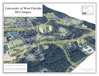
- Discover ArcScene and produce a 3D map
Congratulations to this week's Student Spotlights!
Jennifer Tryggestad
Jennifer currently lives in New Jersey and works for an ocean surveying company. She is a new mom and hopes that by obtaining her GIS certificate she can travel less
and manage more. We hear ya!
What we like: Very nice map design and nice building labels. and manage more. We hear ya!
More: see Jenny's blog
Sandie Vechio
Sandi lives in Arizona and has a BA degree in Advertising/Journalism. She chose the GIS program help her re-enter the work force since her children are in high school. Her interests include GIS in real estate and demographics. Just you wait – Sandi. Applications and Internship are full of information. Great job!
What we like: Clean and well laid out map.
More: see Sandie's blogBryan Hollis
 Bryan is a New Hampshire native and spent a year working on an off shore oil rig in the Gulf of Mexico. He’s back on land and utilizing GIS on a daily basis at his current position. Bryan has never had an official GIS training, but he is doing a great job so far. Check out his 3D model!
What we like: Very nice map - we like the view, colors and labels.
More: see Bryan's blog
More: see Bryan's blog
Christopher Mullins
Chris just finished nine years of active duty with the Navy and currently lives in Augusta, GA where he works as an intel analyst contracting for the government. He has always been interested in the GIS aspect of the intel community and getting a GIS certificate would definitely help his career progression. He’s the proud dad of a toddler and is doing a great job balancing work, the program, and his little girl. Awesome job Chris!
What we like: One of his best, we like the color choices and how easy details read.
More: see Christopher's blog
Michael Supranowicz
Mike lives in Chesire, Massachustets with his wife and cat. He works for the chamber of commerce and is excited about the endless possibilities of GIS and business development. Awesome job this semester Mike!What we like: Nice angle/view and map layout!
More: see Mike's blog


.jpg)


No comments:
Post a Comment
Note: Only a member of this blog may post a comment.