Friday, February 24, 2017

GIS 3015 – Cartographic Skills - Student Spotlight

Module 4: Cartographic Design

Module 4’s lab was the culmination of cartographic design content.  Student’s learned about the Gestalt Principles of perceptual organization, focusing on the concepts of visual hierarchy, contrast, figure ground distinction, and map balance.  The assignment involved creating a map of schools in Ward 7 of Washington D.C. Design concepts were to be utilized to place Ward 7 schools at the top of the map’s hierarchy, while relegating base information, such as roads, to the background.

The spotlight this week goes to Billy Heiden! There were many aesthetically pleasing maps to choose from, however, Billy’s attention to design concept details set his map apart from the rest. Contrast and figure ground is implemented by making Ward 7 the lightest shade in the map, thus appearing closer to the reader and establishing the desired visual hierarchy. The color scheme allows background information to be seen but not overpower, again pulling the eyes to Ward 7 and the schools. The correct level of detail is provided for each region of the map.  In Ward 7, he included finer detail with the DC Streets layer, moving out to the greater D.C. area, only primary transportation routes are included so as not to pull the eye away from Ward 7 and overcrowd the map with superfluous information. Intuitive symbology is applied so that the legend only needs to contain the School layer.   The extent of the map is clearly indicated in the Locator Inset.  Map Balance is achieved by carefully taking advantage of empty map space, ensuring not to bunch elements together or place them in too small of an area. See Billy's blog post for more details about this assignment. Great work Billy!


Tuesday, February 14, 2017

Happy Valentine's Day from GIS Online @ UWF


Make a connection with GIS and celebrate Valentine's Day the Geographer's way! Here is a list of great "mappy" resources to make your Valentine's day memorable.

Friday, February 10, 2017

GIS 4043L – Introduction to GIS Lab - Student Spotlight

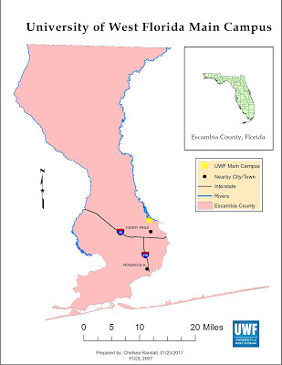
Lab 2: Own Your Map!

The "Own Your Map" Lab encourages students to think creatively when designing their maps. Setting all the essential map elements are key, but creating a map that looks nice and is geared toward your specific audience (the public, customers, etc.) can be challenging.

The spotlight this week is Chelsea Randall! Chelsea's map is well organized, easy to read, and all of the map elements are proportional to each other. None of the map elements are distracting (i.e. North arrow to large, UWF logo awkwardly placed, or city names overlapping roads). Her blog post does an excellent job of discussing the assignment. Great job, Chelsea!


Friday, February 3, 2017

GIS 3015 – Cartographic Skills - Student Spotlight

Module 2: Introduction to CartoGraphic Design with Adobe Illustrator

Module 2’s lab assignment reinforced introductory map design concepts learned in the previous week by allowing students to draft their first map of the class.  The assignment involved creating a basic map of Florida for a children’s encyclopedia.  However, the difficulty of the task  was related to learning and using graphic design software Adobe Illustrator to leverage the map content generated by ArcMap to create a publishable quality end product.

The spotlight this week is Daniella Sabillon! Daniella nailed this assignment by creating a clear and crisp map of Florida using both ArcMap and Adobe Illustrator.  She correctly clipped and displayed Florida’s surface water by category with intuitive color choices.  Daniella effectively ran the provided script in Ai to replace all ArcMap generated city symbols.  Three state images were added to the map, and a drop shadow was utilized to help the content stand apart from the page.  Map space is effectively utilized and the user friendly scale bar promotes quick and easy data acquisition.  Lastly, Daniella’s blog post does an exceptional job introducing the assignment and discussing key skills and processes used to create her map!  Nicely done Daniella!!