Monday, June 27, 2016

GIS 4102/5103 – GIS Programming - Student Spotlight

Module 5: Geoprocessing in ArcGIS


This week in GIS Programming (GIS 5103), students built on previous exercises and practiced several stages of geoprocessing, including making new tools with ArcGIS ModelBuilder, and converting models into scripts and script tools for GIS. For the assignment, students created model and script tools that perform two simple geoprocessing tasks. Further, they learned to share the scripts as a toolbox so that others could use their tools within a GIS environment. Below is an example of the script that students were asked to modify to accept parameters.


Dr. Derek Morgan, the course instructor, writes: Samuel successfully completed all parts of the assignment with flying colors! His blog post is extremely detailed and something to be proud of and he did a great job describing the steps taken to complete this module. Within his blog post he took the time to position informative figures (a flowchart) using the correct standard symbols illustrating the steps he took to automate the geoprocessing steps. 


Samuel has also been a helpful presence on the discussion board helping his fellow students both in this class and the other class he is taking this summer (Applications in GIS).  Along with answering other student's questions from his own coursework experience, he has provided helpful feedback that has helped to keep discussions moving in a positive direction. It is a pleasure to have him in the class. 

Follow Samuel’s progress at his student blog:  http://samuelsong80.blogspot.com

Friday, June 24, 2016

GIS4260/5265 – GIS Applications for Archaeology - Student Spotlight

Module #5: Georeferencing

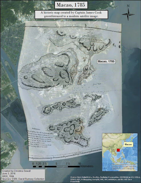
In Module 5, students were tasked with locating historic maps from online sources and importing them into a GIS framework. While the primary focus was identifying levels of georeferencing accuracy and factors that may influence results, this lab also included identifying biases and geographic inaccuracies in the early map documents. The final deliverable was required to include the georeferenced historic maps along with current aerial imagery. It is our hope that students can use these skills to create map documents that will help facilitate modern archaeological research, create compelling results, and enhance their reporting skills for their future research.

This week's STUDENT SPOTLIGHT AWARD goes to... Christina Sewall! Welcome to the Spotlight!


Scott Palumbo, the course instructor, writes: "I chose this lab because her historic map was accurately georeferenced, and because she made good use of her title and mini data frame to provide context to the assignment. Additionally, her blog discussion made it clear how the image was georeferenced, and why such a task might matter to an archaeologist."

Follow Christina's progress at her student blog: http://chrisgisuwf.blogspot.com/

Wednesday, June 8, 2016

GIS4048 – Applications in GIS - Student Spotlight

Module #2: Natural Hazards and Lahars

The Lahars lab is a real cartography challenge! Students conducted geospatial analysis to determine which cities, schools, and populations near Mt. Hood would be most affected by a lahar event. A lahar is a volcanic mudflow or debris flow that has the consistency, viscosity and approximate density of wet concrete: fluid when moving, solid at rest. As a whole, the entire class did an excellent job executing the analysis. The real challenge this week was to create a meaningful map for the entire study area. One student stood out by including an amazing amount of detail in her final map... that STUDENT is... Charmaine Hingada! Welcome to the Spotlight!


Amber Bloechle, the course instructor, writes: "I like how she chose to describe affected areas -- most affected cities share a unique point symbol, symbology for census tracts are classic yellow to dark orange to indicate importance, and nice list of schools is included on the map. Labeling cities was likely the trickiest for students and Charmaine did a great job of meeting the challenge by using a background. Smaller details like county and river labels are also great. Many students included a nice definition of a lahar, which really speaks to the target audience."

Follow Charmaines’s progress at her student blog:  http://ch78gis.blogspot.com/